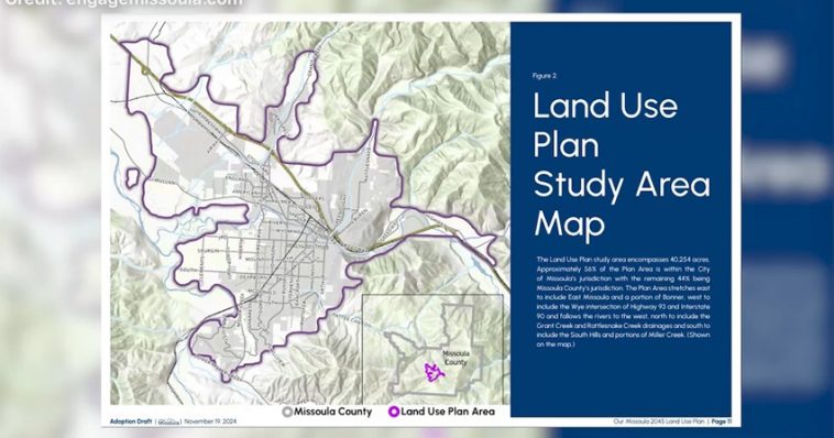
Missoula, MT – The Missoula City Council has formally adopted the city’s 2045 land use plan, a comprehensive framework designed to guide the city’s growth, improve housing affordability, and address climate change over the next two decades. The plan, which was met with both praise and concerns from the community, is the culmination of two years of planning and public consultation.
The land use plan outlines a vision for Missoula’s future, including a detailed map that designates specific types of housing for each neighborhood. This zoning will include areas with high-density housing and mixed-use developments in certain parts of the city, while other areas will see less intense residential development, focusing on single-family homes or rural residential zones.
One of the more contentious areas in the plan is the Rattlesnake neighborhood. While the land use map designates parts of the area for higher-density housing, local emergency services have raised concerns about the potential risks posed by such developments. The Rattlesnake Valley is highly vulnerable to wildfires, and officials worry that increased housing density could complicate evacuation efforts in the event of a disaster. As a result, some high-density proposals for the area are being re-evaluated to balance development with safety.
The adoption of the 2045 land use plan follows months of public meetings, during which residents had the opportunity to share their opinions and voice concerns. One such resident, Gwen Hoppe, expressed unease about the long-term implications of the plan. “It’s kind of scary, going into the next 20 years,” Hoppe said. “We don’t quite know how it’s going to go, but I think it needs a little bit more time to soak in. I don’t think we should rush it.”
Despite the mixed reactions, the plan has garnered significant support from both city officials and community members who recognize the need for action on housing and climate issues.
Ben Brewer, the city’s long-range planning supervisor, provided insight into the development of the plan. “In two years, almost to the day, since the project kickoff in December of 2022, this project was initiated by the city in recognition of the challenges that we face in housing, growth, and development pressure,” Brewer said. He emphasized that the first step following adoption of the plan would be updating the city’s zoning laws and development regulations, setting the stage for the implementation of the land use map and other initiatives.
The land use plan also includes a critical focus on addressing climate change. Originally, the city’s climate goals had a 10-year timeline for action. However, the adoption of the 2045 plan accelerates this timeline, aiming to meet these goals in the next five to nine years. This aligns with broader state and national efforts to reduce carbon emissions and prepare urban areas for the impacts of climate change.
As Missoula looks to the future, the 2045 land use plan sets the stage for a more sustainable, equitable, and livable city. The challenge, however, will be in striking the right balance between growth and environmental sustainability, while addressing concerns from residents about the speed and scope of development.
While some are apprehensive about the plan’s potential consequences, city leaders remain optimistic that the long-term benefits—ranging from more affordable housing to reduced carbon emissions—will make Missoula a stronger, more resilient community in the years to come.
The first signs of change will be evident soon, with updates to zoning laws and development regulations set to roll out in the coming months. As Missoula moves forward, residents will be watching closely to see how the 2045 plan unfolds, and whether it lives up to its promise of a more sustainable, inclusive future.


